In 2012, Auckland Council released the City Centre Masterplan. It had strong support from the council, and the public who submitted on it. Perhaps the cornerstone was a plan to pedestrianise Queen Street, a fantastic idea in itself, but not the topic of today’s post.
The key element I want to talk about was a “green stitch”, a series of connections between the city centre’s main parks: Victoria Park, Albert Park, the Domain, and a proposed new park on the headland at Wynyard Quarter.
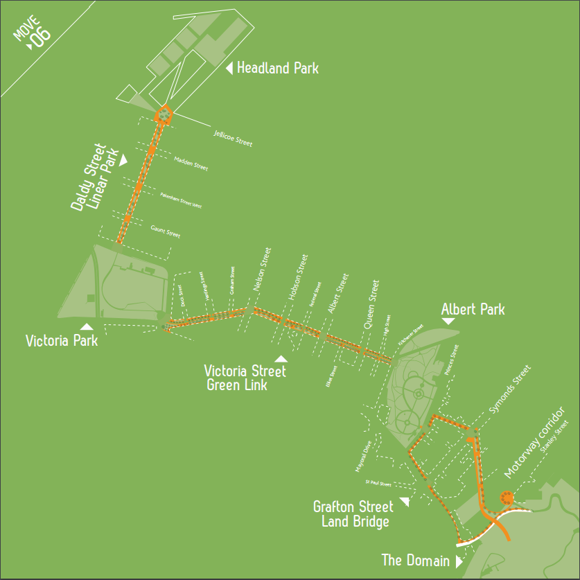
The heart of this was the Victoria Street Linear Park. Vehicle traffic on the street would be reduced to the bare minimum - one lane each way, and no parking. Through traffic and buses would be removed from route. With the space freed up, most of the street would become a long thin park, on the south side to get maximum sun.
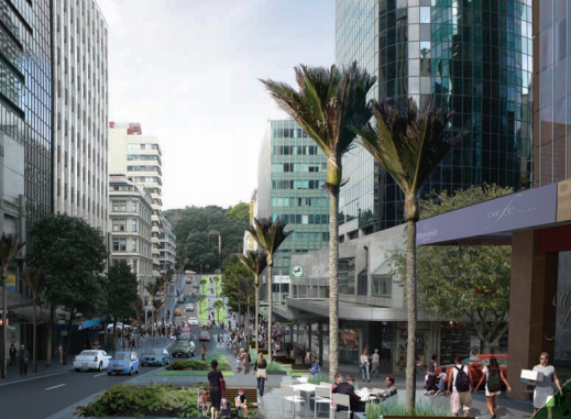
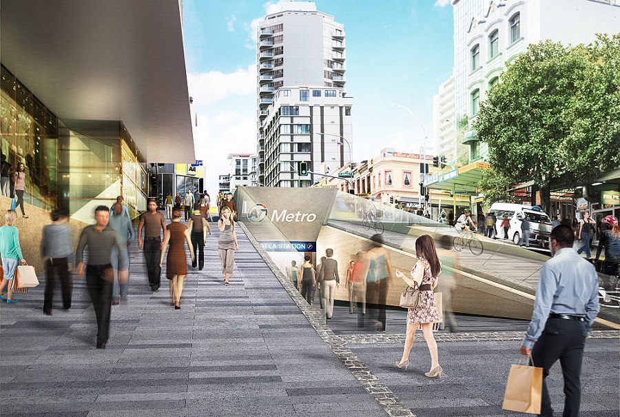
This would provide valuable open space and greenery in the heart of the city centre. It would also provide space for the tens of thousands of people due to pour out of Aotea Station once the City Rail Link is built.
So far, so good. There were a few hiccups - the plan couldn’t happen immediately, due to the actual construction of the City Rail Link. Victoria Street is also a route for buses, but Victoria Street wouldn’t have the room to handle them with the Linear Park. So they’d have to find an alternative route. Which would be good for the buses, anyway. The Victoria Street route had numerous twists and turns, more intersections, and in rush hour was frequently stuck for up to half an hour going one block on Waterloo Quadrant to where the bus lanes began.
Buses also only used Victoria Street heading out of the city: they already came on Wellesley Street, instead, a block away. This was confusing and inconvenient for passengers, who would not be able to catch a bus back from where they had been dropped off, and would suddenly need to figure out that the departing buses took a totally different route.
Fortunately, Auckland was planning a ground-up rearrangement of bus services anyway, which included Wellesley Street becoming the new main east-west route for buses. Wellesley Street is straighter, with fewer traffic lights and conflicts. Plenty of buses already used it. So the sensible solution would be to dedicate Wellesley Street to buses (removing general traffic). Four bus lanes and associated bus stops, no cars.
Having Wellesley Street as a two-way bus corridor offered some other opportunities as well. Extending the route a few blocks up Halsey Street into Wynyard Quarter would finally provide a decent public transport service to that fast-growing area, currently only served by the excruciatingly slow City Link bus. Indeed, the bus network was going to include a bus interchange in Wynyard Quarter.
But then…1
Enter Auckland Transport
The City Rail Link grinded slowly on, as did the rearrangement of Auckland’s buses, both of which would need to be underway (if not completed) before the Linear Park could begin. At first, some nasty rumours began to surface - Auckland Transport (AT) was having difficulty getting a site for the bus interchange in Wynyard. AT had got pushback about sending buses up Wellesley Street from the top brass at the University of Auckland, who apparently didn’t want any unsightly buses anywhere near the campus, despite being how most of their students arrived.
AT was running a series of consultations on the new network for different parts of the Auckland Region, staggered over time. The consultation for the part covering the central city ended up being last. By the time it finally happened, there was a shock: AT no longer planned to get buses off Victoria Street, and no longer planned to make Wellesley Street a dedicated “transit mall”2.
Plenty of people submitted against this, but AT stuck with it into the final plans, now due to be implemented later in 2017.
And then things got worse. Auckland Transport admitted they wanted to kill the Victoria Street Linear Park permanently. They wanted to keep four lanes of traffic on Victoria Street as well. Even pedestrianising Queen Street was now too hard. They reported back to Council that there were “conflicts” with the council’s Linear Park plan.
At this point the councillors lost their patience, and delivered a harsh rebuke to Auckland Transport. The case for the Linear Park was as strong as ever. They had approved a plan for a city centre targeted at people, not cars, and they wanted it delivered.
The junior guy Auckland Transport sent to the meeting agreed: they’d make it happen. The council resolved to uphold the City Centre Masterplan and move forward with the Linear Park.
Wait, I thought “Auckland Transport” was the council
I should explain first how Auckland Transport works. Auckland Transport is not part of the Auckland Council as such, the way that, say, the Parks department or Resource Consents are. Auckland Transport is a subsidiary of the council, and a “Council-Controlled Organisation”. With the amalgamation of Auckland’s local governments in 2010, it was set up deliberately at arm’s length from the council proper. The council would still set its budget, appoint the board, and give strategic direction, but councillors would not be able to interfere in day-to-day operations.
This was not a recipe for success. It meant an organisation that had no effective political control, and no effective commercial control, spending half of the council’s budget and affecting every other area of the council’s business. But still, this is the model we have today. An organisation that accounts for about half of what we expect Auckland Council to do is only barely under control by the council that supposedly “controls” it.
Which explains what happened next.
Auckland Transport’s stealth war on the linear park
A few days after supposedly capitulating, Auckland Transport had a new tactic. Suddenly, and secretly, on a Friday afternoon, they quietly set up a webpage taking submissions on “route options out of the city centre” for the buses currently using Victoria Street. The Wellesley Street option was not favoured: they wanted “Option One”: the status quo.
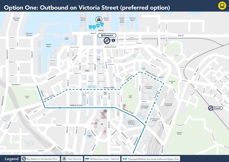
Supposedly, Wellesley Street had a whole host of disadvantages compared to Victoria Street:
- This route would require buses to use an uphill slip lane to reach Symonds Street, and introducing more buses to this narrow, pedestrian-filled area would be challenging.
Except… the buses already used the downhill equivalent of that slip lane, just as narrow, and with far more pedestrians, because it was a more direct walking route.
- This route would require new traffic lights to enable buses to turn right out of the slip lane into Symonds Street, which would delay other buses using Symonds Street.
Except… the intersection already has traffic lights, used to allow cars to make a right turn into the downhill equivalent of that slip lane.
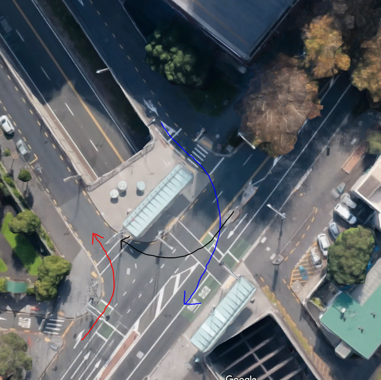
Red: inbound buses on Wellesley Street. Blue: the right turn buses would make outbound. Black: a turn for cars that currently has a dedicated traffic light phase
Prohibiting cars from making that right turn, or even entering the slip lanes entirely, would solve that even if it were an issue.
- This route does not serve the northern parts of the University of Auckland campus well, meaning staff and students would have to walk further to get to and from buses.
Except… no-one would walk any further from buses, since inbound buses would use Wellesley Street either way. As for going to the buses, it would add a few minutes walk from a few parts of the campus of one of the two universities, level, and across the campus staff and students routinely walk across all day.
And for the other university, AUT, the route would be worse: you would need to walk uphill to Symonds Street to catch a bus.
- Buses will need to turn and layover near Victoria Park. This is an area with limited space available and may cause delays for passengers.
Which is true, at least. But it brings us back to a point from earlier. These buses were supposed to be extended to a terminus to serve Wynyard Quarter, which would render the point moot. Clearly, that has dropped through a crack in the Earth.
Meanwhile, Victoria Street had only the throwaway comment:
- This route will make it difficult to reduce the number of lanes on Victoria Street, as part of a planned future upgrade of Victoria Street.
Admitting that their preferred option would make it impossible to build the Linear Park. Which the Council, supposedly their bosses, had reiterated support for just days earlier.
The Battle for Victoria Street
The title of this post comes from friend of the blog, Harriet Gale, who mounted a swift Twitter campaign in defence of the Linear Park. The battle found allies, not least councillor Richard Hills, who described himself as “pissed”, as well he should. We can only hope the war is won.
No, wait. We can do more than hope.
So after all that, dear reader, is where you come in. If you want the Victoria Street Linear Park, tell Auckland Transport that, on their feedback page, by Monday 24 April. Tell them you want Option Two, which was supposed to happen all along, and the Linear Park.
¡Viva el parque lineal!
Notes
-
Irrelevant to anything, but a chance to throw in a reference to one of my favourite films. “one day in June, a knock at the door was to change all that”. ↩
-
A transit mall is a surface street entirely for public transport. Buses travel at city speeds, and stop for pedestrian crossings and traffic lights, but do not have to compete with cars or parking. This would mean buses could travel the length of Wellesley Street unimpeded by traffic all the way to Symonds Street, which would have the traditional bus lanes it does right now. ↩